Drone River Inspection for Underground Canals
Key Benefits at a Glance
|
Access With only outdated 2D maps to guide them, the Elios 3 was deployed during low tide to enter underground canals that had not been accessed since construction. This made it possible to safely conduct a drone river inspection. |
Data Quality The team captured clear visual data, including photos and videos, along with a detailed LiDAR scan that impressed the client. The data collected exceeded the original mission scope without requiring extra work. |
|
Safety Entering this environment is nearly impossible due to fluctuating water levels and strong currents. The Elios 3 provided the only safe and effective solution for the task. |
Speed All data was collected in just one day, whereas traditional methods would have required several days of planning and setup. |
Urban water management involves more than just sewage—it also includes rivers, freshwater, and grey water systems. Rivers are often channeled into canals to make them easier to manage. These can be part of a city’s infrastructure, like in Birmingham or Venice, or they may run underground. However, when canals are buried, their condition plays a crucial role in whether construction can proceed above ground. Inspections, however, are extremely challenging.
Divers often find these spaces too dangerous due to unknown risks, while some underwater ROVs may struggle with strong currents or get stuck inside. So what's the alternative? Enter the Elios 3 drone—now a go-to tool for accessing complex and confined areas safely and efficiently.
The Elios 3 drone is quickly becoming a key player in urban water inspections, offering a safer and more efficient way to explore hidden spaces.
Planning a Drone River Inspection for an Underground Canal
Sater is a water and wastewater management company based in northern France, near Lille. As part of the SARP group, which is under Veolia, Sater has over 30 years of experience and currently employs 115 people across France. They specialize in inspecting hard-to-reach environments using remote-controlled cameras and similar tools.
Recognizing the value of drones in water management, Sater recently acquired the Elios 3 to enhance its inspection capabilities. This decision proved critical during a recent project in Rouen, where they needed to inspect underground canals before starting surface-level construction.
Inspecting Canals with Drones
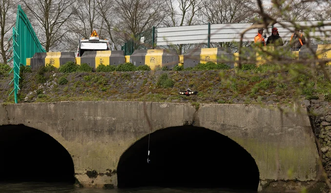
At the Marché d'Intérêt National (MIN) in Rouen, a river flows beneath the buildings and streets before emptying into the Seine. Before any construction could begin, the structural integrity of the underground water network had to be assessed.
Two parallel canals transport water under structures, and their condition needed to be checked before any surface work could proceed.
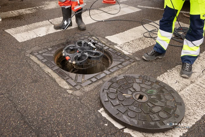
This type of inspection is highly risky for divers, especially due to the tides in the Seine. The mission had to be timed carefully to account for water level fluctuations. The canals were 540 meters long, with manholes every 50 meters, and each opening was only 2 x 3 meters wide.
Completing the Drone River Inspection Underground
With no up-to-date maps available, the Sater team relied on historical charts. The mission took place in early April, during low tide, allowing the Elios 3 to fly through both tunnels. Using its visual camera and LiDAR, the pilot navigated the drone even when it was out of sight, ensuring a safe return.
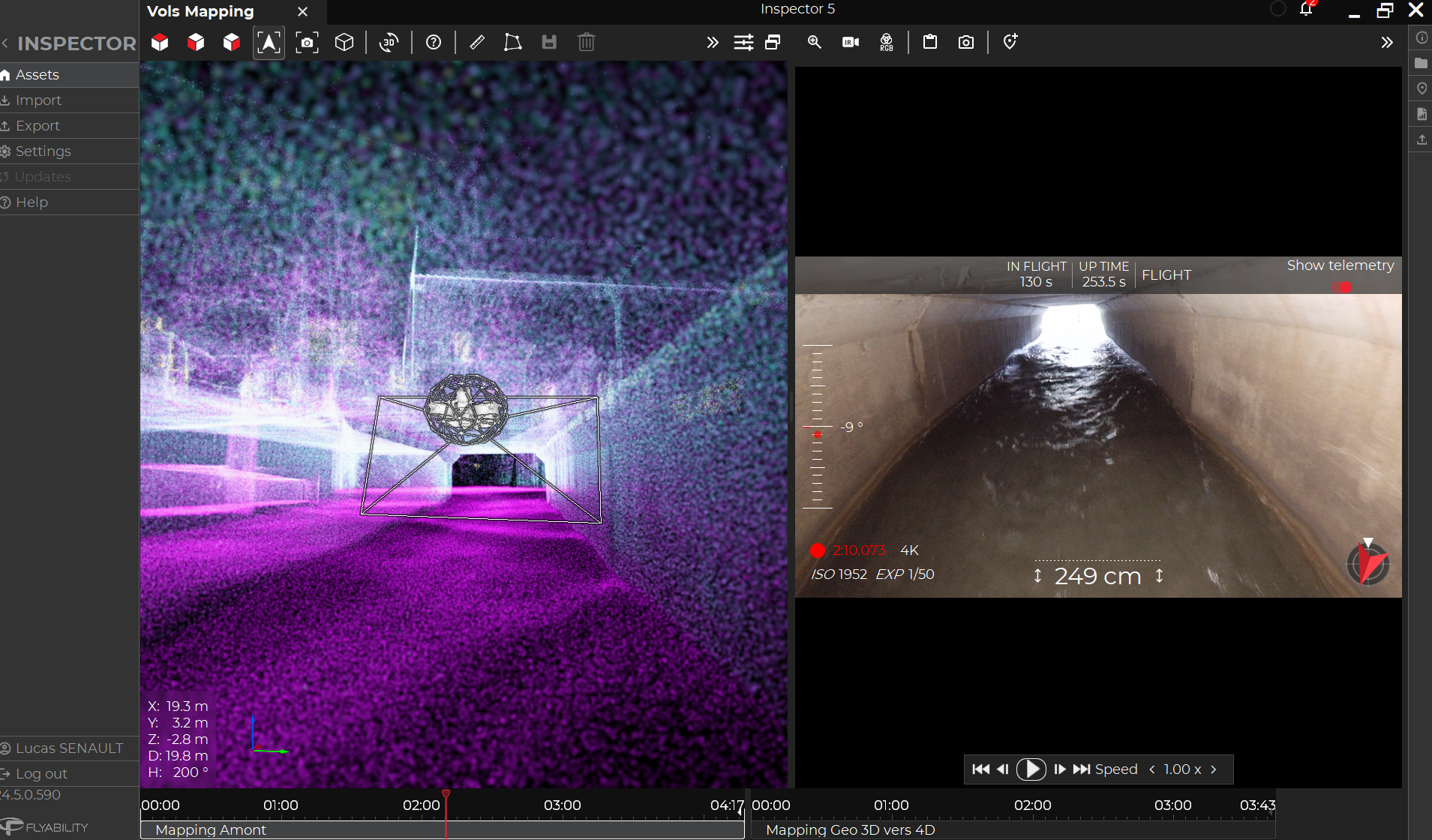
The LiDAR point cloud and visual camera allowed the pilot to navigate the Elios 3 safely, even in low visibility conditions.
The drone successfully reached inaccessible areas and collected high-quality data. Not only did it provide video footage, but it also captured detailed LiDAR scans, which were used to create a precise 3D model of the canals.
Impressing the Municipality with Drone Results
The client was particularly pleased with the LiDAR scans, which offered a clear and accurate view of the underground canals. This 3D model provided valuable insights without exposing personnel to risk. The results not only met the needs of the local authorities but also set Sater apart from competitors.
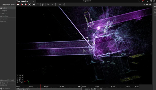
The LiDAR scan helped the team visualize the area clearly, providing useful data for future planning and record updates.
This mission not only showcased the power of drone technology in urban water management but also opened the door for more ambitious projects in the future. Without the Elios 3, collecting this data safely would have been nearly impossible.
Agri Machinery,Farm Machinery,Agriculture Machine,Agriculture Machine Price
Shandong Yineng Heavy Industry Co.,Ltd , https://www.yinengloader.com